| 《地理成像儀插件》(Avenza Geographic Imager)v3.3 for Photoshop CS4|CS5|CS5.1[壓縮包] | |
|---|---|
| 下載分級 | 软件资源 |
| 資源類別 | 多媒體類 |
| 發布時間 | 2017/7/11 |
| 大 小 | - |
《地理成像儀插件》(Avenza Geographic Imager)v3.3 for Photoshop CS4|CS5|CS5.1[壓縮包] 簡介: 中文名 : 地理成像儀插件 英文名 : Avenza Geographic Imager 資源格式 : 壓縮包 版本 : v3.3 for Photoshop CS4|CS5|CS5.1 發行時間 : 2011年 制作發行 : Avenza Systems Inc. 語言 : 英文 簡介 : Avenza Systems公司為Adobe公司的產品提供了很多插件,最出名的
電驢資源下載/磁力鏈接資源下載:
全選
"《地理成像儀插件》(Avenza Geographic Imager)v3.3 for Photoshop CS4|CS5|CS5.1[壓縮包]"介紹
中文名: 地理成像儀插件
英文名: Avenza Geographic Imager
資源格式: 壓縮包
版本: v3.3 for Photoshop CS4|CS5|CS5.1
發行時間: 2011年
制作發行: Avenza Systems Inc.
語言: 英文
簡介:
Avenza Systems公司為Adobe公司的產品提供了很多插件,最出名的就是MAPublisher制圖工具。Geographic Imager 3.3是這一系列軟件的最新版本,該版本將地理空間功能加入了Adobe Photoshop。
“隨著最初Geographic Imager的成功發布,我們非常高興繼續支持Adobe Photoshop 的產品並更新其中的一些功能,” Avenza 公司銷售總監Doug Smith說,“我們現在為Adobe公司的最新Photoshop產品提供空間影像功能支持,並將進一步從總體上加強Adobe Photoshop軟件中的空間影像處理功能。”
使用該插件後,Photoshop可以有以下的功能:
- 在不破壞空間屬性質量的情況下進行Photoshop自帶功能的使用;
- 載入空間柵格數據,並保留控制點信息;
- 輸出其它格式的柵格數據;
- 使用地面空間點對沒有配准的數據進行匹配;
- 修改空間影像的投影信息;
- 空間影像的自動鑲嵌操作;
- 基於地理坐標的影像裁剪功能;
- 同Photoshop相關功能的協同工作;
- 支持多圖層和多譜影像的空間轉換;
- 地理數據向GeoTIFF格式的轉化;
- 新增地理坐標系統數據文件;
- 對Mac和Windows的多重支持;
- 對Vista/7系統的支持。
Working with raster imagery doesn't have to be complicated. Geographic Imager® enhances Adobe Photoshop to make working with spatial imagery quick and efficient. It adds tools to import, edit, manipulate and export geospatial images such as aerial and satellite imagery. Enjoy the use of native Adobe Photoshop functions such as transparencies, filters, pixel editing, and image adjustments like brightness, contrast, and curve controls while maintaining spatial referencing.
Geographic Imager supports GeoTIFF in Adobe Photoshop and other industry standard raster formats. Mosaic and tile images, change projections, transform, rectify and georeference images based on ground control points. Batch-process your imagery using Geographic Imager and Adobe Photoshop scripting capabilities. Geographic Imager is a great companion to MAPublisher for Adobe Illustrator—prepare images in Geographic Imager and use them in MAPublisher.
Feature Highlights
Georeference images easily by adding ground control points. Manually add control points, import or export points from a text file, and view accuracy and errors. Use the Quick Georeference option to make georeferencing even easier. Multiple transformation types are supported.
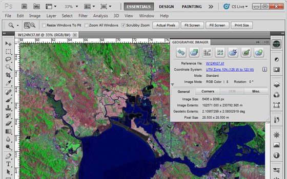
Geographic Imager Panel
Redesigned for Adobe Photoshop CS5, the Geographic Imager® panel provides access to all the tools and functions quickly and easily. All spatial information related to a GeoTIFF, DEM, ECW, MrSID or other supported image including the co-ordinate system, world location of the corners and pixel size are displayed along with buttons to access the various Geographic Imager functions. More time is left to edit geospatial data rather than searching for tools.
Retain Spatial Properties
Geographic Imager allows the use of Adobe Photoshop native functionality without destroying the spatial properties of a GeoTIFF, DEM, ECW, MrSID or other spatial image. Easily manipulate and adjust the visual elements such as colour values and levels, histograms, hues and sharpness. Spatial properties of the image are automatically updated and retained even after performing crop, rotate or geospatial adjustments. This is important in industries such as photogrammetry and remote sensing where it is necessary for analysis.
Import and Export Spatial Imagery
improved . Import and manage georeferenced imagery in Adobe Photoshop such as GeoTIFF, NITF, PCI and other compatible raster data formats, including support for CIR, RGBI and other multispectral and multichannel data. Advanced Import allows you to crop images during the import process (before they are opened), making it a great way to crop large images.
Geospatial PDF support
Create Adobe Acrobat PDF files containing coordinate systems from Geographic Imager image or import and modify existing Geospatial PDF documents. Easily share or publish them online. Find locations, measure distances, perimeters and areas, add locations markers and customize export settings. Take the geospatial PDF maps on the go using the PDF Maps iOS app.
Import Elevation Data
Import DEM formats such as ArcInfo ASCII Grid, ArcInfo Binary Grid, USGS DEM ASCII/CDED, Military Elevation Data/DTED and SRTM. Assign a DEM Schema during import for easier rendering. Overlay aerial photography to create custom looking images.
Terrain Shader
Create shaded relief maps from DEM data in Adobe Photoshop quickly and easily using the Terrain Shader feature. Control intensity and lighting source. Define elevation intervals for custom colour ramps.
Georeference Imagery
Import or add ground control points for accurate georeferencing of aerial photography or satellite imagery with multiple transformation types supported. Assess residual errors to improve geoferencing and save control point data as reference files. Quick Georeference by a single tie point, two tie points, or from other documents.
Transform
Extensive support for thousands of geographic and projected coordinate systems with the ability to save custom definitions for future use. Re-center images using a custom central meridian and modify pixel resolution.
Mosaic
Mosaic raster images to create a seamless image. Retain images as separate layers or flatten to create one image. Now supports image transformation during Mosaic, making it easier to get the images the way you want. Also, now create seamless mosaics of images with different coordinate systems, pixel sizes, channels and colour modes.
Tile
Tile raster data into multiple images by tile size or count and automatically saves tiles using sequential naming into any supported spatial image format. Great for turning large satellite images into smaller tiles and serving them online.
GeoCrop
The GeoCrop tool allows image cropping based on a combination of pixels or geographic coordinates (geodetic and projected). Easily define coordinates or draw a crop area to see a preview. Advanced Import allows you to crop images during import, making it a great way to crop large images without the need to open them first.
Merge and Split Channels
Adobe Photoshop Merge and Split Channels are now supported. Useful for remote sensing, create false- and true-colour images and retain all georeferencing.
Automate Tasks
Create scripts and actions of Geographic Imager and Adobe Photoshop tools to automate repetitive tasks. All Geographic Imager tools are compatible with automation.
Home Page - http://www.avenza.com/geographic-imager
代碼
英文名: Avenza Geographic Imager
資源格式: 壓縮包
版本: v3.3 for Photoshop CS4|CS5|CS5.1
發行時間: 2011年
制作發行: Avenza Systems Inc.
語言: 英文
簡介:
Avenza Systems公司為Adobe公司的產品提供了很多插件,最出名的就是MAPublisher制圖工具。Geographic Imager 3.3是這一系列軟件的最新版本,該版本將地理空間功能加入了Adobe Photoshop。
“隨著最初Geographic Imager的成功發布,我們非常高興繼續支持Adobe Photoshop 的產品並更新其中的一些功能,” Avenza 公司銷售總監Doug Smith說,“我們現在為Adobe公司的最新Photoshop產品提供空間影像功能支持,並將進一步從總體上加強Adobe Photoshop軟件中的空間影像處理功能。”
使用該插件後,Photoshop可以有以下的功能:
- 在不破壞空間屬性質量的情況下進行Photoshop自帶功能的使用;
- 載入空間柵格數據,並保留控制點信息;
- 輸出其它格式的柵格數據;
- 使用地面空間點對沒有配准的數據進行匹配;
- 修改空間影像的投影信息;
- 空間影像的自動鑲嵌操作;
- 基於地理坐標的影像裁剪功能;
- 同Photoshop相關功能的協同工作;
- 支持多圖層和多譜影像的空間轉換;
- 地理數據向GeoTIFF格式的轉化;
- 新增地理坐標系統數據文件;
- 對Mac和Windows的多重支持;
- 對Vista/7系統的支持。
Working with raster imagery doesn't have to be complicated. Geographic Imager® enhances Adobe Photoshop to make working with spatial imagery quick and efficient. It adds tools to import, edit, manipulate and export geospatial images such as aerial and satellite imagery. Enjoy the use of native Adobe Photoshop functions such as transparencies, filters, pixel editing, and image adjustments like brightness, contrast, and curve controls while maintaining spatial referencing.
Geographic Imager supports GeoTIFF in Adobe Photoshop and other industry standard raster formats. Mosaic and tile images, change projections, transform, rectify and georeference images based on ground control points. Batch-process your imagery using Geographic Imager and Adobe Photoshop scripting capabilities. Geographic Imager is a great companion to MAPublisher for Adobe Illustrator—prepare images in Geographic Imager and use them in MAPublisher.
Feature Highlights
Georeference images easily by adding ground control points. Manually add control points, import or export points from a text file, and view accuracy and errors. Use the Quick Georeference option to make georeferencing even easier. Multiple transformation types are supported.
Geographic Imager Panel
Redesigned for Adobe Photoshop CS5, the Geographic Imager® panel provides access to all the tools and functions quickly and easily. All spatial information related to a GeoTIFF, DEM, ECW, MrSID or other supported image including the co-ordinate system, world location of the corners and pixel size are displayed along with buttons to access the various Geographic Imager functions. More time is left to edit geospatial data rather than searching for tools.
Retain Spatial Properties
Geographic Imager allows the use of Adobe Photoshop native functionality without destroying the spatial properties of a GeoTIFF, DEM, ECW, MrSID or other spatial image. Easily manipulate and adjust the visual elements such as colour values and levels, histograms, hues and sharpness. Spatial properties of the image are automatically updated and retained even after performing crop, rotate or geospatial adjustments. This is important in industries such as photogrammetry and remote sensing where it is necessary for analysis.
Import and Export Spatial Imagery
improved . Import and manage georeferenced imagery in Adobe Photoshop such as GeoTIFF, NITF, PCI and other compatible raster data formats, including support for CIR, RGBI and other multispectral and multichannel data. Advanced Import allows you to crop images during the import process (before they are opened), making it a great way to crop large images.
Geospatial PDF support
Create Adobe Acrobat PDF files containing coordinate systems from Geographic Imager image or import and modify existing Geospatial PDF documents. Easily share or publish them online. Find locations, measure distances, perimeters and areas, add locations markers and customize export settings. Take the geospatial PDF maps on the go using the PDF Maps iOS app.
Import Elevation Data
Import DEM formats such as ArcInfo ASCII Grid, ArcInfo Binary Grid, USGS DEM ASCII/CDED, Military Elevation Data/DTED and SRTM. Assign a DEM Schema during import for easier rendering. Overlay aerial photography to create custom looking images.
Terrain Shader
Create shaded relief maps from DEM data in Adobe Photoshop quickly and easily using the Terrain Shader feature. Control intensity and lighting source. Define elevation intervals for custom colour ramps.
Georeference Imagery
Import or add ground control points for accurate georeferencing of aerial photography or satellite imagery with multiple transformation types supported. Assess residual errors to improve geoferencing and save control point data as reference files. Quick Georeference by a single tie point, two tie points, or from other documents.
Transform
Extensive support for thousands of geographic and projected coordinate systems with the ability to save custom definitions for future use. Re-center images using a custom central meridian and modify pixel resolution.
Mosaic
Mosaic raster images to create a seamless image. Retain images as separate layers or flatten to create one image. Now supports image transformation during Mosaic, making it easier to get the images the way you want. Also, now create seamless mosaics of images with different coordinate systems, pixel sizes, channels and colour modes.
Tile
Tile raster data into multiple images by tile size or count and automatically saves tiles using sequential naming into any supported spatial image format. Great for turning large satellite images into smaller tiles and serving them online.
GeoCrop
The GeoCrop tool allows image cropping based on a combination of pixels or geographic coordinates (geodetic and projected). Easily define coordinates or draw a crop area to see a preview. Advanced Import allows you to crop images during import, making it a great way to crop large images without the need to open them first.
Merge and Split Channels
Adobe Photoshop Merge and Split Channels are now supported. Useful for remote sensing, create false- and true-colour images and retain all georeferencing.
Automate Tasks
Create scripts and actions of Geographic Imager and Adobe Photoshop tools to automate repetitive tasks. All Geographic Imager tools are compatible with automation.
Home Page - http://www.avenza.com/geographic-imager
代碼
▄                                                                           ▄
  ▀▀▀▀▀▀▀▀▀▀▀▀▀▀▄▄▄▄▄▄▄▄▄▄▄▄▄▄▄▄▄▄▄▄▄▄███▄▄▄▄▄▄▄▄▄▄▄▄▄▄▄▄▄▄▄▄▄▄▀▀▀▀▀▀▀▀▀▀▀▀▀▀
                                 ▄▄▄██▀███▄▄▄▄
                              ▄███▀▀▀▀█▓█▀▀▀▀███▄
                             ██▀   ░▓ █░█ ▓░   ▀██
▀█▄▄                       ███     ░ █░█ ░     ▓██         ▄▄▄▄▄▄▄▄  ·    ▄▀
    ▄▄▓▓▓▓▄▄▄    ▄▄▄▄▄▄▄   ▐██      ▄▄█ █▄▄      ██▌  ·▄▄▄▓█▀▀▀░░▓▓▓██▄▄▄▄·
       ·     ·▀▀▀▒▒▓▀▀     ██▓   ▄█▀█▄▄▄▄▄█▀█▄   ▓██                 ▀▀▀
                           ██░  ███████████████  ░██
                     ▄█▀█▄ ██░ ██▄███████████▄██ ░██ ▄█▀█▄
                    ▐▀████▄██▓██▄█████████████▄██▓██▄████▀▌
                    ▐▄█▓██▀████▒███████████████▒████▀██▓█▄▌
                     ▀█▄█▀  ███ ███████████████ ███  ▀█▄█▀
                             ▀▀█████████████████▀▀         ▀   ▀▄
                                 █           █              █▄  █▓
                            ▄   █             █   ▄        ·█▓  ██
                             ▀▀▀▀             ▀▀▀▀         ▓█▀ ▓██
                        ▄▄                                ███ ███▓
        ▄▄▄       ▄ ▄▄▀▀    ▄                  ▓▒▄▄      ▀█▀ ▄███·
           ▀▀▀▀▄▄▄▄▄▄▄▄▄▄▄▄▄█▄▄                  ▀███ ▄ ▀   ▄██▓
                 ▄▓████▀▀▀▀ █           ▓▓░▄▄      ▀      ▄███▀
            ▄▄▀ ███████▀▀▄▄▄             ▀▀████         ▄██▀▀
          ▀▀     ▄█▄▄█▄                      ▀       ▀▀·
        ▄▄▄▄▄          ▄▄▄▄█       ▄▄▄▄█       ▄▄▄▄▄    ▄█      ▄▄
       ▓███▀███▄   ▓███▀▀██▓░  ▄███▀▀███▓  ▓███▀▀███▓  ▓▓██   ▓███
    ░░ ████  ███▓ ░████       ▄████ ░███▓  ████  ███▓▄▄▄▄▄▄▄  ▓███    ░░
       ████ ░███▓  ██████▓    ░████  ▀▀▀   ████ ░███▓  ▓███   ▓███
    ▄ ▄████▄███▀   ████ ▄▄▄▄▄▄▄████  ▓███▀▀████ ░███▓  ▓███   ▓███ ▄▄▄▄▄▄ ▄
       ████▀███▄   ▀███▄▄████ ░████▄▄███▓  ████▄▄███▓  ▓███░░░▓███  ███▓
       ▀▀▀▀  ▀███▄ ░▓▀▀▀▀▀▓▀    ▀▀▀▀▀▀▀▀    ▀▀▀▀▀▀▀▀  ▀▀▀▀▀▀▀▀▀▀▀▀▀▀▀▀▀  zk.
               ▀██▓      ▄▓▄
                   ▀      ▀             █▄ ▄▄▄▄▄▄▄▄▄▄▄▄▄▄▄▄▄▄▄▄▄▄▄▄▄▄▄▄▄▄▄
                                ▄▄▄▄▄  ▄████████████████████████████████████▓░
   ░▄                    ▄▓░▒▓█████▓░█░████████▓█████████████████████████████▓
   ▓█             ▄█████▓██░▓█████████░████▀▀█▀▀██▀▀▀▀▀▀▀▀▀▀██▀▀▀▀█▀██▀▀▀▀███▓
  ▄█▄█▄▄▄▄▄▄▄▄▄▄██▓▄▄▄▄▄▄▓█░▓█▄▄█▄▄▄▄█░▄▓▒░██████████████████████████████████▓
░▓█████████████████████████▓█████████████░███▀▀▀▀▀▀▀▀▀▀▀████████████████████▓
   ▀▀■▄▄▄▄▄▄▄▄▄▄▀▓▒░▄▄▄▄▄███░▀████████████▓██▄ ░░░░░░░░░▄████▀███████████████▓
                          ▀░▓▓▀▀▀▀▀▀▓███▓▀  ▀▀▀▀▀▀▀▀▀███████▄████▄████████▀█▓░
                                      ▀▀       ▀░░░▓▓▄▄▓▒▄▓ █   █ ▀██████▓
                                                ░██▓███████ █  ▀   ▓██████▓
                                                ▓████████▓█  ▀▄▄▄▄▀ ████████
                                                ██▓██▓████▓          ████████
                                               ▓████████▓█            ▓██████▓
                                              ▓██░██▓██▓█▓             ▓█████▓
                                             ▓██░██▓██▓█▓               ▓████▓
                                           ▄██░███░█████                 ▀▀▀▀▀
                                        ▄▄██░███░██▓██▓
                                      ████▓███░██▓███▀
─ ──────────────────────────────────   ▀████▓██▓███▀  ─────────────────────── ─
   ░▓█████████████████████████████▓░░    ▀██████▀▀  ░░▓███████████████████▓░
─ ──────────────────────────────────── ─   ▀▀▌▀   ─────────────────────────── ─
       ▓                                                               ▓
  ▄ ▄████▓▓▄▄▄ ▄   ▄       [ MOST PROUDLY PRESENTS ]       ▄   ▄ ▄▄▄▓▓████▄ ▄
      ▓█▓                                                             ▓█▓
       ▓                                                               ▓
       ░                                                               ░
               Geographic Imager v3.3 for Photoshop CS4 CS5 CS5.1
                                 (c) Avenza
                            Date ..... : 2011-05-19
                            Size ..... : 26 x 5.00MB
                            Protection : RLM
                            Type ..... : Plugin (CS4/CS5/CS5.1)
                            OS ....... : Windows
       ░                                                               ░
       ▓                                                               ▓
      ▓█▓                                                             ▓█▓
░ ▓▓████▓▓▄▄▄ ▄   ▄                                       ▄   ▄ ▄▄▄▓▓███▓▓░ ░
─ ─────────────────────────────────────────────────────────────────────────── ─
   ░▓█████████████████████▓░  [ RELEASE NOTES  ]  ░▓██████████████████████▓░
─ ─────────────────────────────────────────────────────────────────────────── ─
   Working with raster imagery doesn't have to be complicated. Geographic
   Imager enhances Adobe Photoshop to make working with spatial imagery
   quick and efficient. It adds tools to import, edit, manipulate and
   export geospatial images such as aerial and satellite imagery. Enjoy the
   use of native Adobe Photoshop functions such as transparencies, filters,
   pixel editing, and image adjustments like brightness, contrast, and
   curve controls while maintaining spatial referencing. Geographic Imager
   supports GeoTIFF in Adobe Photoshop and other industry standard raster
   formats. Mosaic and tile images, change projections, transform, rectify
   and georeference images based on ground control points. Batch-process
   your imagery using Geographic Imager and Adobe Photoshop scripting
   capabilities. Geographic Imager is a great companion to MAPublisher for
   Adobe Illustrator-prepare images in Geographic Imager and use them in
   MAPublisher.

   http://www.avenza.com/geographic-imager
─ ─────────────────────────────────────────────────────────────────────────── ─
   ░▓█████████████████████▓░  [  INSTALLATION  ]  ░▓██████████████████████▓░
─ ─────────────────────────────────────────────────────────────────────────── ─
   Unzip, Unrar. Check /crack
─ ─────────────────────────────────────────────────────────────────────────── ─
   ░▓█████████████████████▓░  [   GROUP iNFO   ]  ░▓██████████████████████▓░
─ ─────────────────────────────────────────────────────────────────────────── ─
        We are not taking any applications. We are an invite only group.
─ ─────────────────────────────────────────────────────────────────────────── ─
   ░▓█████████████████████▓░  [   GREETINGS    ]  ░▓██████████████████████▓░
─ ─────────────────────────────────────────────────────────────────────────── ─
           Our friends, our loyal members and our fair competitors.
                             You know who you are.
─ ─────────────────────────────────────────────────────────────────────────── ─
   ░▓████████████▓░  [ RECOiL IN 2011 - ONE MORE IMPACT! ]  ░▓████████████▓░
─ ─────────────────────────────────────────────────────────────────────────── ─
- 上一頁:《多媒體綜合處理軟件》(MEDIARevolution)v3.7.8[壓縮包]
- 下一頁:《地圖設計出版插件》(Avenza MAPublisher)v8.4.2 for Illustrator CS4|CS5[壓縮包]
相關資源:


- [應用軟件]《如師通》(rosetta stone)多語言版本。數據盤。需要主程序(詳見簡介部分)[光盤鏡像]
- [行業軟件]《專業DJ工具軟件》(Native Instruments Traktor Pro 1.1.1)[壓縮包],行業軟件、資源下載
- [多媒體類]《專業音頻現場降噪修復增效軟件》(Diamond Cut DC8)更新v8.02/含注冊機[壓縮包]
- [應用軟件]《AUTODESK 2013 產品通用注冊機》( AUTODESK 2013 PRODUCTS UNIVERSAL KEYGEN )WINDOWS & MACOSX[壓縮包]
- [多媒體類]《數碼照片編輯軟件》(Odin Frame Photo Creator)v5.4.2[壓縮包]
- [軟件綜合]機械設計手冊 2.0 (軟件版)+破解及補丁
- [應用軟件]《幻燈片產生工具》(AnvSoft Photo DVD Maker Professional)v8.21/含注冊機[壓縮包]
- [操作系統]《Microsoft Windows 2000 高級服務器安裝版》
- [行業軟件]《天文制圖》(MaxIm DL Pro Suite v5.03)[壓縮包],行業軟件、資源下載
- [應用軟件]《FlyakiteOSX v3.0》(FlyakiteOSX v3.0),應用軟件、資源下載
- [電子雜志]《2015年《科學》》(Science)更新至10.30(國內外雜志最速更新)[PDF] 資料下載
- [行業軟件]《AKTA重做系統》(AKTA Unicorn 5.11)5.11[壓縮包],行業軟件、資源下載
- [電子雜志]《elle日文原版2010年》(elle)全12刊 [壓縮包] 資料下載
- [學習課件]《ggplot2:數據分析與圖形藝術》資料下載
- [文學圖書]《歷史·理解·意義:歷史诠釋學》(韓震&孟鳴歧)掃描版[PDF]
- [系統工具]《驅動程序管理工具》(Driver Genius Professional Edition)v11.0.0.1112專業便攜版/多國語言版[壓縮包]
- [計算機與網絡]《瘋狂Java講義》掃描版[PDF]
- [軟件綜合]電腦加速!充分利用你電腦的大內存虛擬世界上最快的硬盤!【內附教程】——剛才失敗了,sorry
- [人文社科]《中國圖騰文化》掃描版[PDF]
- [生活百科]《實用經絡點穴療法》掃描版[PDF] 資料下載
- 《C4d Vray 渲染插件》(Vray)1.2[壓縮包]
- 《威力導演10》(CyberLink PowerDirector Ultra 10)v10.0.0.1012/多國語言含簡繁中文/含注冊機和升級補丁[壓縮包]
- 《音效合成工具》(PROPELLERHEADS.REASON.V3.0.ISO-RiSE)[Bin]
- 《音頻文件創建編輯工具》(CyberPower Audio Editing Lab)v15.2.2/含注冊碼[壓縮包]
- 《音樂工作站》(Propellerheads Reason)v3.0 For MAC[Bin]
- 《DVD視頻質量解決方案》(DVD Ranger )v4.0.2.8[壓縮包]
- 《SnagIt 10 截圖軟件》(TechSmith SnagIt) v10.0.0 Build 788 簡體中文漢化版 [安裝包]
- 《音頻格式轉換工具》(Protected Music Converter)v1.9.7.5[壓縮包]
- 《強大序列幀播放器合集》(PdPlayer/framecycler/DJV/AnimPlayer)1.0.1.28/v3.5_sp2/0.8.3-pre2_winxp-x86(32位破解版)/1.60
- 《Maya骨骼插件》(AdvancedSkeleton for maya)1.85-3.6.1[壓縮包]
- 《音樂繪譜軟件》(Sibelius 6.2.0.88 Multilingual)[光盤鏡像]
- 《演進電吉他》(Evolution Electric Guitar
免責聲明:本網站內容收集於互聯網,本站不承擔任何由於內容的合法性及健康性所引起的爭議和法律責任。如果侵犯了你的權益,請通知我們,我們會及時刪除相關內容,謝謝合作! 聯系信箱:[email protected]
Copyright © 電驢下載基地 All Rights Reserved