- 下載位址: [www.ed2k.online][交互式GIS和影像處理].idrsan15.part1[www.xuexi111.com].rar
- 下載位址: [www.ed2k.online][交互式GIS和影像處理].idrsan15.part2[www.xuexi111.com].rar
資料介紹
軟件名稱: IDRISI Andes V15.0 (交互式GIS和影像處理)
程序語言: 英文
軟件分類: 國外軟件 / 零售版 / 天文地理
文件大小: 488M
評價星級: 5
整理日期: 2006-5-13 11:15:49
頁面刷新: 2006-05-13 12:02:54
適用平台: 98/Me/NT/2000/XP/.Net/
[已通過安全檢測]SYMANTEC.ANTIVIRUS.CORPORATE.V10.0.2.2000(英文精簡版本)
[已通過安裝測試]WinXP+SP2和WIN2003專業版 WIN98
軟件版權歸原作者及原軟件公司所有,如果你喜歡,請購買正版軟件
共享服務時間:每天:8點至24:30點
共享服務器:DonkeyServer No3 . DonkeyServer No9
DRISI Andes是一個交互式GIS和影像處理解決方案,提供了200個模塊來分析和處理數字空間信息。IDRISI提供了業界最廣泛的GIS和影像處理工具。這些工具包括土地規劃、決策支持、風險分析等等。包括:對空間數據統計,地表分析,空間建模的分析。
IDRISI Andes V15.0 於2006年4月釋放,這是自1987年以來,第15次發行的有關IDRISI Andes版本。IDRISI目前已在超過175個國家被廣大研究員和專業人士使用。
With IDRISI Andes, you can:
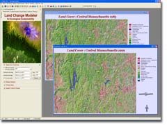
Explore, predict, and model impacts on land cover change with the innovative Land Change Modeler facility.
The Land Change Modeler for Ecological Sustainability is organized around a set of tasks for land cover change assessment, change prediction, assessment of its impacts on habitat and biodiversity, and the exploration of planning interventions.
Process remotely-sensed imagery with a full suite of image processing techniques including innovative
soft classifiers and neural network and decision tree analyses.
IDRISI has incomparable classification tools. Machine learning classifiers consist of three neural network classifiers--multi-layer perceptron, self organizing map, and fuzzy art map.
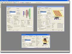
Utilize cutting-edge decision support and uncertainty management tools to allocate resources and create suitability maps.
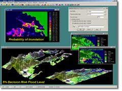
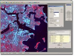
This screenshot illustrates some of the data products developed for a study on the effects of sea level rise on a coastal rice-producing area in Vietnam. Part of the study included prediction of future sea level and inundated areas. This portion of the study explicitly incorporated uncertainty in the elevation data as well as the projected sea level rise. The probability of inundation image (upper left) was then thresholded based upon an acceptable level of risk. The multi-criteria analysis was a prediction model of where people might relocate after inundation, thus a predicted landcover image was produced
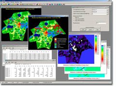
Compare pairs of images or analyze trends and anomalies from long time series imagery.
IDRISI provides the most extensive set of change and time series analysis tools in the industry. This screenshot illustrates Markov Chain Analysis, a technique for predictive change modeling. Predictions of future change are based on changes that have occurred in the past.
Import/export with a wide variety of data sources, including all major vector and imagery formats.
IDRISI supports the import of HDF-EOS 4 format which is useful for importing ASTER and MODIS data.
And even more…
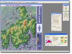
IDRISI provides full map composition capabilities, including multiple raster and vector layers, layer blending, interactive RGB compositing, multiple legends, title, text labels, grid, north arrow, scale bar, text and image insets. This image depicts the White Mountain region in New Hampshire, USA, including data for elevation, roads, and boundaries using various layer blending options
- 上一頁:《土地測量》(Autodesk Survey)V2007[Bin]
- 下一頁:《IMSI Design CAD 3DMax 16.2 2D設計》(IMSI Design CAD 3DMax 16.2)英文[ISO]


- [行業軟件]《數據三維可視化工具》(Ceetron.GLview.Inova)v8.3.11[壓縮包]
- [行業軟件]《設計精確度量工具》(xScope )v3.1 Mac OS X[壓縮包]
- [應用軟件]《個人信息管理工具》(CSoftLab C-Organizer Professional)v4.5[壓縮包]
- [軟件綜合]自建博客需要的一些東東 //能不能把燕子的搜索好好做做啊,搜索很爛的說啊!
- [操作系統]《openSUSE 10.3 正式版本》(openSUSE 10.3 )10.3 [ISO]
- [多媒體類]《4Media Software多媒體轉換處理軟件產品》(4Media Software)v6.5.2 詳見各版本號[壓縮包]
- [安全相關軟件]《網絡浏覽隱私安全軟件》(Giant Matrix iSurfer Shield)v1.0.5/含破解補丁/更新至v2.18[壓縮包]
- [編程開發]《Eclipse 插件》(WireframeSketcher Studio)v3.1.1[壓縮包]
- [系統工具]《硬盤維護工具》(Ashampoo HDD Control 2 )v2.10 Multilingual[壓縮包]
- [軟件綜合]電腦公司 GhostWin7
- [其他資源綜合]《股票培訓課程--殷保華講座》[壓縮包]
- [應用軟件]《蘋果頂級壓縮軟件 StuffIt Deluxe 9.0.1》(StuffIt Deluxe)9.0.1,應用軟件、資源下載
- [行業軟件]《CAD/CAE/CAM一體化軟件》(DASSAULT SYSTEMES CATIA V5R18 SP6)多語版 Win32/64[ISO],行業軟件、資源下載
- [生活圖書]《家常海鮮》掃描版[PDF]
- [人文社科]《綠帽子》(Green Hat)電影原版(國語)[RMVB]
- [光盤游戲]《貴族重生》(Highborn)[光盤鏡像]
- [多媒體類]《3D動畫編輯工具》(Worldweaver.DX.Studio.Professional.Edition)v3.2.7[壓縮包]
- [多媒體類]《Aquafadas照片幻燈片制作工具》(Aquafadas PulpMotion Advanced)v3.1.0高階版/蘋果版/注冊版[光盤鏡像]
- [計算機與網絡]《Web滲透技術及實戰案例解析》掃描版[PDF]
- [軟件綜合]《IE用戶福利~ Adblock Plus for IE 官方版本》(Adblock Plus for IE)0.8.470.0[壓縮包]
- 《3D CAD數據綜合處理》(DeskArtes 3Data Expert)v9.1.0.10[壓縮包]
- 《電子設計自動化》(SynaptiCAD Product Suite v13.26a)[壓縮包],行業軟件、資源下載
- 《Solid Edge 5CD豪華增強版》(Solid Edge)v17 帶授權文件[Bin]
- 《建築結構設計》(AUTODESK REVIT STRUCTURE SUITE V2011)含破解/x32+x64[光盤鏡像]
- 《EDA 仿真軟件 Tina Pro v8.0》(Designsoft Tina Pro V8.0)最新版[壓縮包]
- 《CAD/CAM/CAE集成軟件》(PTC Creo 2.0 U110 Win32/64)英文版[光盤鏡像]
- 《油氣體視覺化軟件》(Tecplot RS 2009)[壓縮包]
- 《客戶關系管理》(Combit Relationship Manager)v6.001[壓縮包]
- 《財易人事管理軟件》(cyrsgl.V3.15)安裝版[壓縮包]
- 《客戶關系管理》(PGCSoft CRM-Express Professional)v2011.2.1.0[壓縮包]
- 《全國GPS智能語音導航和查詢軟件——城際通銳思》
- 《ProgeCAD2007專業版》(ProgeCAD 2007 Professional v7.0.3)
免責聲明:本網站內容收集於互聯網,本站不承擔任何由於內容的合法性及健康性所引起的爭議和法律責任。如果侵犯了你的權益,請通知我們,我們會及時刪除相關內容,謝謝合作! 聯系信箱:[email protected]
Copyright © 電驢下載基地 All Rights Reserved