資料介紹
相關專題學習資料:- 3D處理軟件工具
Geoweb 3D 是一個獨立的GIS可視化應用程序,可以創建先進的三維地理信息系統數據圖形 它是專為不具備軟件開發經驗或三維圖形知識用戶,而提供的全面和精干的地理可視化產品。
該產品集成了3D可視化引擎,Web浏覽器引擎,和ArcGIS Engine在一個輕松的學習,創新的用戶界面,直觀和有趣的使用軟件包內。
Due to the economy of scale of the gaming industry, commodity hardware now has the capability to produce high-fidelity geospatial visualization and analysis directly from native GIS data. The 3D engine maximizes use of the GPU to remove conventional barriers with respect to size, resolution, and complexity.
Geoweb3d entered the GIS market because, for the first time, it could offer this military-grade visualization to the commercial geospatial community at a reasonable cost.
Using your GIS data
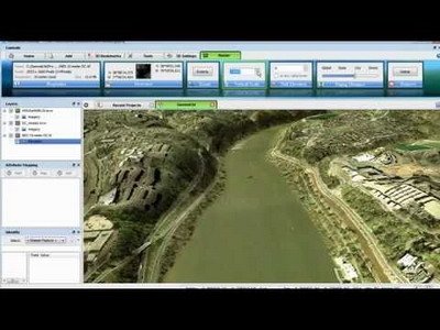
Geoweb3d has direct, native support for most commonly-used raster and vector GIS formats, and on the fly reprojection means no preprocessing of data. Users add their own GIS data to Geoweb3d to generate rich 3D scenery for viewing and analysis. Drag in unaltered data and immersive, detailed 3D scenes are just a few clicks away.
Embedded Browser and ArcGIS
Geoweb3d Desktop embeds a full web browser and ArcGIS Engine to provide the most comprehensive GIS visualization solution for today’s GIS users. Integrating the web brings effortless interoperability with the growing volume of online geospatial content.
Using a tabbed approach similar to a web browser, any number of 3D, web, and ArcGIS views can be opened for a seamless GIS workflow.
Easy to use
Geoweb3d Desktop was designed for those users who desire more capable geospatial visualization – not 3D experts. The user interface represents a new concept of modern contextual design that makes 3D simple and intuitive.
Thematic rendering
3D visualization is all about effectively communicating information to others. Often, this requires that realistic content be supplemented with thematic representations of data. A hybrid of realistic and thematic visualization is good for emphasizing areas and layers of interest. A user may also create alternative presentations of the same location and switch between them simply by clicking a checkbox.
CAD / BIM 3D model support
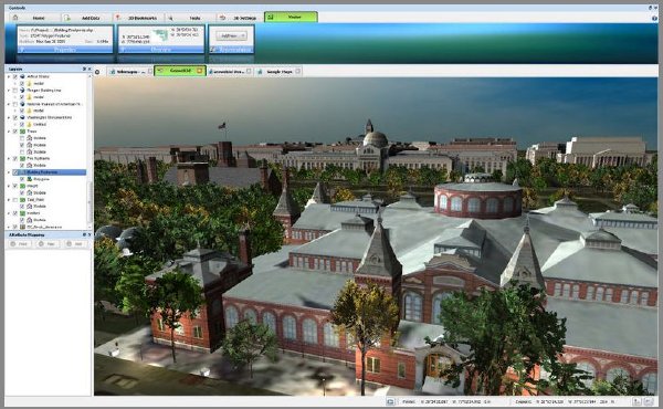
Users with high-fidelity 3D models from CAD resources may place them in their proper geographic location and fuse them with GIS data, feeds, web services, and more.
3D buildings do not need to be simple textured boxes as much as trees don’t need to be simple polygon models. You have the hardware already, let Geoweb3d provide the software that puts it to work.
- 上一頁:《電腦美術繪畫軟件》(Corel Painter)v12.0.1.727/含注冊機[壓縮包]
- 下一頁:《交通信號燈配時/通行能力分析及仿真軟件》(Trafficware Synchro Studio)v7.0[壓縮包]


- [軟件綜合]屏幕動作錄制工具
- [應用軟件]《點訊梅花6》(PlumSIP6)6.0[安裝包],應用軟件、資源下載
- [行業軟件]《歐特克三維交互式產品演示軟件》(AUTODESK INVENTOR PUBLISHER V2011 R1)Win64+Win32[光盤鏡像]
- [軟件綜合]3D Studio Max 2016
- [系統工具]《誤刪除文件恢復軟件》(Active@ Undelete Enterprise)v7.4企業版/含注冊碼[壓縮包]
- [軟件綜合]《VisualAge for Java 4.0 企業版》(VisualAge for Java 4.0 Enterprise&#
- [軟件綜合]強烈推薦:<<開心熱鍵精靈v1.20(已破解)>>,一款設置全局熱鍵的超強軟件。
- [多媒體類]《AE畫冊坊(自助編輯畫冊)》(AlbumEditor.v1.2.3)綠色免費版[壓縮包]
- [行業軟件]《統計軟件spss 16》[archiver],行業軟件、資源下載
- [軟件綜合]《歐特克Inventor.2010簡體中文版》(Autodesk.AutoCAD.Inventor.Suite.v2010)
- [生活圖書]《形象設計》文字版[PDF]
- [其他圖書]《【京華出版社】二十世紀風雲人物(更新1本)》
- [人文社科]《戰爭論》掃描版[PDF]
- [文學圖書]《50後上海人說事》掃描版[PDF]
- [生活圖書]《筍類美食108》掃描版[PDF]
- [行業軟件]《有限元分析》(ANSYS PRODUCTS V14)WIN64[光盤鏡像]
- [游戲周邊]《最終幻想12cg》(Final.Fantasy.X-2.Original.CG )
- [人文社科]《ASP.NET項目開發案例全程實錄(第2版)》掃描版[PDF]
- [學習課件]《做自己的頸椎醫生》(王強虎)文字版[PDF] 資料下載
- [光盤游戲]《瘋狂橄榄球2004》(Madden NFL 2004)[Bin]
- 《數控編程系統》(SURFWARE.SURFCAM.V2004.SP1)[Bin]
- 《CAD/CAM/CAE集成軟件》(Creo Elements/Pro 5.0 M110 Win32/64)簡體中文(多國語言)版[光盤鏡像]
- 《Gambit 2.4.6 +Exceed 13》(Gambit 2.4.6 +Exceed 13)Gambit 2.4.6 +Exceed 13[光盤鏡像]
- 《MapInfo 9 專業版》(MapInfo.Professional.v9.0.Build.42)
- 《歐特克工藝流程圖繪制軟件》(AutoCAD P&ID V2012)更新V2012/WIN32+64/含破解[光盤鏡像]
- 《沖壓成形分析》(Fastform 10.3)國外軟件 / 零售版 / 制造行業,行業軟件、資源下載
- 《電影特效制作 Houdini》( SideFX Houdini Master v10 Final Win32/64)[壓縮包]
- 《建築三維渲染軟件》(Abvent Artlantis Studio)v4.0.16 Multilingual x86 x64[壓縮包]
- 《平面三維全能CAD》(CADopia 6.0 Pro + SP1)
- 《P-CAD 2006 PCB設計軟件》(P-CAD 2006)2006
- 《會計電算化練習系統》(lianxixitong)08年版[ISO],行業軟件、資源下載
- 《SolidWorks Office Premium繁體中文版》(SolidWorks Office Premium)V2007 SP0.0[ISO],行業軟件、資源下載
免責聲明:本網站內容收集於互聯網,本站不承擔任何由於內容的合法性及健康性所引起的爭議和法律責任。如果侵犯了你的權益,請通知我們,我們會及時刪除相關內容,謝謝合作! 聯系信箱:[email protected]
Copyright © 電驢下載基地 All Rights Reserved