資料介紹
相關專題學習資料:- 3D處理軟件工具
3D World Atlas
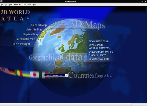
Dorling Kindersley (DK) 出品的三維電子世界地圖,真實再現整個地球的 3D 模型,猶如身處太空俯視地球一樣。可通過滑鼠拖動自由旋轉,點選一個國家,會蹦出有關這個國家詳情的視窗。地圖提供縮放功能和五種不同的查看方式,可自由切換。
使用時先執行 AutoRun.exe 安裝,之後便可以從硬碟或是光碟來開啟程式。支援 Windows 98/2000/XP 作業系統。
DK的歷史
1974年 Peter Kindersley 和 Christopher Dorling 建立 DK 公司。他們的願望就是創作既有視覺沖擊力又包含信息豐富的圖書,使讀者能夠理解每一個主題。DK 圖書被認為是從出生到年老不斷學習的生活指南。
DK 在開始的時候像一個工作室,為其他出版商創作圖書,並且從那時候國際化就成為 DK 圖書的重要理念。
使用更多的圖片使 DK 圖書在一開始就與眾不同,它強調圖文並茂,這使 DK 圖書更易於閱讀和理解。同時也旨在創作能夠在市場中長期銷售的書,DK 很多70年代創作的書至今已經賣出了上百萬冊,而且現在還不斷改版,重印。如攝影大師 John Hedgecoe 的“New Book of Photography”《新攝影手冊》,“Complete Book of Mother and Baby Care”《媽媽寶寶護理大全》,“the First Aid Manual”《急救手冊》,這些書也被翻譯成中文出版銷售。在國際上最為暢銷 DK 圖書是於1988年開始出版的目擊者指南系列“Eyewitness Guides Series”,這套書以44種語言在世界各地銷售超過5500萬冊。
1982年,DK 開始在英國以自己的商標出版圖書,並很快成為知名品牌。DK 還和世界知名組織如紅十字會、Smithsonian 研究所、皇家園藝協會等,建立聯系,進行合作,很快使 DK 的品牌更加值得信賴。
現在DK 已經延伸到不同類型的出版,從迪斯尼、夢工廠等的特許出版到適於成人的旅游指南、懷孕、保健、電腦技術以及適於兒童的百科、科普、活動書籍等。同時DK也更多嘗試將內容以網絡和數碼的形式呈現給讀者,保持與不斷發展的市場保持同步。
關於DK
DK 與中國出版界有著長期的合作歷史。1992年 DK 第一次來到中國,參加了北京國際圖書博覽會。1994年 DK 與廣西接力出版社簽署了第一份版權協議――《媽媽寶寶護理大全》,這本書至今已經成功銷售120,000冊。
1997年 DK 建立了北京辦事處,郭志平先生為辦事處的首席代表。2000年何奕女士成為 DK 北京辦事處的一員。現在 DK 北京辦事處與培生集團旗下的其他兄弟公司在北京東城區共享一個辦公環境。
目前 DK 每年有50-100本書在中國出版。這些書既有針對成人讀者的也有適合少年兒童的,主題涵蓋母嬰護理、體育健康、自然歷史、攝影旅游、百科辭典、兒童科普讀物以及園藝等多個方面。
在中國的暢銷的圖書除接力出版社的《媽媽寶寶護理大全》還有外研社的《ELT多級閱讀》、北京出版社的《透視眼叢書》、童趣出版社的《視覺奇觀系列》、時尚出版社的《全新攝影手冊》、上海科技出版社的《人體》等。
DK 在中國的目標就是與中國的出版合作伙伴建立長期穩定的合作關系,為成功創作出版適合於每個人的圖書提供有力支持。
2006年9月 DK 中文網正式運行。DK 一直關注通過多種方式加強與中國出版合作者密切的合作,推動由中國出版社出版的 DK 圖書在市場上獲得成功。
DK主頁:
http://www.dk.com/
3D World Atlas
Product Features
- Hot links lead you to helpful geographic information
- Virtual technology renders flat maps as 3D globes
- Unique 'horizon' view of planet Earth
- Measure the distance between two or more locations
- Shows latitude/longitude co-ordinates
- Print or copy maps, text, and graphics
- Country Overviews cover: Climate, Education, People, Economy, Crime, Wealth
- Politics, Environment, Tourism, and history
a 3D atlas of the world, as you'd expect
Okay, let's throw out a tangential line here. What if you were an alien, visiting Earth - imagine that. If otherworldly inspiration lets you down, just pretend you're Bill Bailey or Grace Jones. What's the first thing you'd do? Aside from wondering (a) What that wet stuff falling from the sky is (assuming you're in England); ( b ) What the hell an "asshole" is (if you're Stateside) and © Why do DJ's exist? Hint: "Take me to your leader" is a complete non-starter.
But navigation would be an important consideration, so nipping to the nearest software retailer and picking up a copy of 3D World Atlas would be high on the list of beneficial possibilities. It would be a font of edification in which to bathe your extraterrestrial mind, with knowledge of the geographical, political and social aspects of our planet. Or would it?
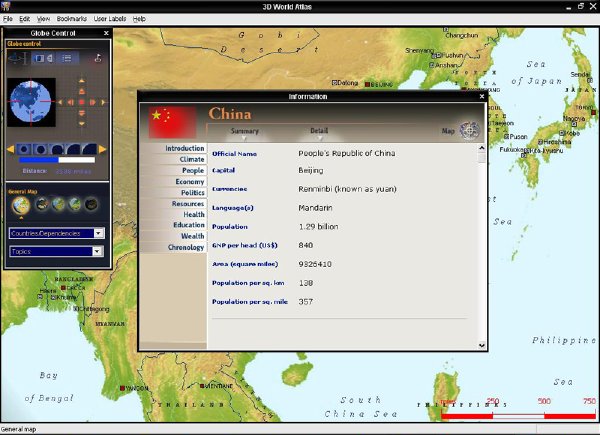
This program is quite simply what it says on the box - a 3D model of the globe you can spin around with your mouse hand. Graphically it's reasonably impressive and the globe scrolls fairly smoothly. Click on any country and you're offered a chance to examine detailed statistics concerning the place.
These go into some depth, with information provided on population, level of education, crime, tourism, along with economic and political status (with some very interesting and detailed pieces of text on these sections). Much of this is commendably current, covering up until the end of last year.
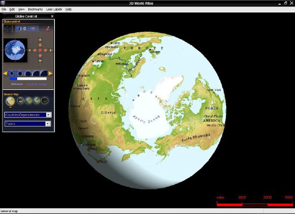
There are five different modes of display into which the globe can be switched, with five levels of zoom. These include a general map, a physical map showing tectonic plates and volcanoes, a satellite view displaying physical features such as mountains (you can click on any mountain or river to see its name, although no further info is offered), along with bio-geographic zones and an earth-by-night view.
Along with this solid core material, extra content is provided in the form of Earth-related topics. Those that wish to learn about the environment, natural disasters, the global climate and similar issues can explore a range of sub-topics based on these themes. They're rather skimpily detailed however, and only a few photos are provided with some concise text.
It seems that developer Dorling Kindersley missed the chance to really flesh these extras out. The multimedia content is pretty scarce and they could have gone to town with videos in these sections. Still, it wasn't to be.
Nevertheless, the program is fundamentally concrete and well presented. It also boasts an easy to use interface and some smart extras like the ability to bookmark any number of places on the map and add your own comments, along with a distance tool to measure the miles between any number of points.
Dorling Kindersley - 3D World Atlas features - Verdict
Essentially this is a well presented atlas containing a good range of informative details on every country in the world. The interface is well thought out and easy to use, although the multimedia content is rather weak and the developer could have done much more with certain sections of the disc. It's a fair price to ask, however, for a fairly impressive program.
Reviews
Amazon.co.uk Review
Travel has never been more popular. Yet no matter how many footloose gap-year students stream to the corners of the globe, armchair travel probably remains almost as popular. Dorling Kindersley's 3D World Atlas is a new CD-ROM package firmly in the armchair bracket, giving in-depth coverage of every country in the world--from maps, through demographic statistics to information on geographical phenomena. Why move from the sofa when you can (virtually) experience the world in your living room?
3D World Atlas includes the range of features you would expect from a printed atlas and more. The general world maps are set to an optimal scale, allowing different levels of focus, and there are also the physical maps to view. However, the most striking aspect of this package is its unusual features, particularly those that come from space.
The two satellite image-projections of the earth are revealing. First comes the ordinary view of the earth's physical features from the heavens--yes, you really can pick out the Great Wall of China--and then an image of the earth by night, showing all the lights around the world: it's a sparkly and revealing picture of the spread of economic development across the planet. Add to this brilliant photography of deserts, mountains and jungles in the bio-climate zones and the package transcends the limitations of traditional atlases. --Toby Green
Manufacturer's Description
From Pole to Pole, this stunning, interactive 3D world atlas lets you explore the world as never before! 3D World Atlas is a complete, concise, and exciting way to explore the world. Featuring over half a million mapped locations, 3D World Atlas provides a level of detail to satisfy even the most demanding traveler or researcher.


- [應用軟件]《桌面時鐘軟件》(Sharp World Clock)v5.83[壓縮包]
- [應用軟件]《建模仿真》(MATHWORKS.MATLAB.7.0.4.R14.SP2)[Bin],應用軟件、資源下載
- [應用軟件]PDF虛擬打印機破解版
- [系統工具]《並行桌面(蘋果平台專用)》(Parallels Desktop for Mac)8.0.18483.860857[安裝包]
- [安全相關軟件]《大蜘蛛反病毒軟件去廣告便攜版》(Dr.Web CureIt!)更新v7引擎版本[壓縮包]
- [行業軟件]《三維數據可視化軟件》(Golden Software Voxler)更新v2.3.1125 Win64/含注冊機[壓縮包]
- [行業軟件]《Xmanager3 企業版》(NetSarang Xmanager Enterprise v3.0.0181)[壓縮包]
- [行業軟件]《人員緊急疏散模擬軟件》(Thunderhead Engineering Pathfinder)v2011.1.1128/含授權文件[壓縮包]
- [系統工具]《系統備份還原完整解決方案》(FarStone TotalRecovery Pro)專業版v7.1.2/含注冊機[壓縮包]
- [多媒體類]《AVC視頻轉換器》(Any Video Converter Ultimate)v4.3.4終極版/多國語言含簡體中文[壓縮包]
- [學習課件]《皮膚性病驗方精編》掃描版[PDF] 資料下載
- [其他圖書]《邊玩邊賺錢 36種潮流達人職業》彩圖版[PDF]
- [編程開發]《英特爾® Visual Fortran 編譯器 Windows 專業版》( Intel Visual Fortran Compiler Professional ) v11.1.038[光盤鏡像],編程開發、資源下載
- [經濟管理]《稀缺》(Scarcity:Why Having Too Little Means So Much)文字版 [EPUB]
- [多媒體類]《彩繪大師 4.0》(Piranesi 4.0)Version 4.0[ISO]
- [行業軟件]《有限元前後處理及分析系統》(MSC Patran V2010)WIN32/WIN64[光盤鏡像]
- [電腦基礎]《神奇的美畫師:CorelDRAW 12中文版基礎應用全接觸》(CorelDRAW 12)隨書光盤[壓縮包]
- [生活百科]《中國姓氏辭典》掃描版[PDF] 資料下載
- [學習材料]《唐詩宋詞鑒賞大典》(Appreciation for tangshi songci)典藏版[PDF] 資料下載
- [光盤游戲]《巫師之怒2》(Rage of Mages 2)中文正版光盤鏡像[ISO]
- 《差異分析工具》(Altova DiffDog Enterprise 2011)v13.0.1.0/含注冊機+補丁[壓縮包]
- 《眼睛衛士 v3.0 Pre》(EyeGuard3.0)[壓縮包]
- 《Esker Tun Plus終端模擬器》(Esker Tun Plus 2006 v13.0)[Bin],應用軟件、資源下載
- 《Macromedia FlashPaper 綠色版》(Macromedia FlashPaper)2.2,應用軟件、資源下載
- 《強力安全刪除軟件》(BCwipe 6.04)6.04[安裝包]
- 《ACDSee Pro 2 圖象處理軟件》(ACDSee Pro 2 v2.5.358 )更新 v2.5.363[壓縮包]
- 《單詞黑客--GRE、四六級、考研英語詞匯速記軟件》[壓縮包]
- 《虛擬現實軟件》(Quest3D)Quest3DV4.3[壓縮包]
- samsung kies官方中文版 4.0.16011
- 《寶馬歐洲道路電子地圖專業版 》(BMW Road Map Europe )HIGH DVD 2009-02 MultiLanguage[光盤鏡像]
- 《復合材料分析與結構優化》(Hypersizer Pro V5.3)[光盤鏡像],應用軟件、資源下載
- 《照片編修插件》(OnOne Software PhotoTools Professional)更新v2.6.2專業版/含注冊機[壓縮包]
免責聲明:本網站內容收集於互聯網,本站不承擔任何由於內容的合法性及健康性所引起的爭議和法律責任。如果侵犯了你的權益,請通知我們,我們會及時刪除相關內容,謝謝合作! 聯系信箱:[email protected]
Copyright © 電驢下載基地 All Rights Reserved