| 《地理成像儀軟件PS插件》(Avenza Geographic Imager for Photoshop)v3.2.1[壓縮包] | |
|---|---|
| 下載分級 | 软件资源 |
| 資源類別 | 多媒體類 |
| 發布時間 | 2017/7/11 |
| 大 小 | - |
《地理成像儀軟件PS插件》(Avenza Geographic Imager for Photoshop)v3.2.1[壓縮包] 簡介: 中文名 : 地理成像儀軟件PS插件 英文名 : Avenza Geographic Imager for Photoshop 資源格式 : 壓縮包 版本 : v3.2.1 發行時間 : 2010年 制作發行 : Avenza Systems Inc 地區 : 加拿大 語言 : 英文 簡介 : Avenza Systems公司宣布為Adobe Photoshop 發布G
電驢資源下載/磁力鏈接資源下載:
全選
"《地理成像儀軟件PS插件》(Avenza Geographic Imager for Photoshop)v3.2.1[壓縮包]"介紹
中文名: 地理成像儀軟件PS插件
英文名: Avenza Geographic Imager for Photoshop
資源格式: 壓縮包
版本: v3.2.1
發行時間: 2010年
制作發行: Avenza Systems Inc
地區: 加拿大
語言: 英文
簡介:
Avenza Systems公司宣布為Adobe Photoshop 發布Geographic Imager 3插件。該公司已經為Adobe公司的產品提供了很多插件,最出名的就是MAPublisher制圖工具。Geographic Imager 是這一系列軟件的最新版本,該版本將地理空間功能加入了Adobe Photoshop。
“隨著最初Geographic Imager的成功發布,我們非常高興繼續支持Adobe Photoshop 的產品並更新其中的一些功能,” Avenza 公司銷售總監Doug Smith說,“我們現在為Adobe公司的最新Photoshop產品提供空間影像功能支持,並將進一步從總體上加強Adobe Photoshop軟件中的空間影像處理功能。”
使用該插件後,Photoshop可以有以下的功能:
在不破壞空間屬性質量的情況下進行Photoshop自帶功能的使用;
載入空間柵格數據,並保留控制點信息;
輸出其它格式的柵格數據;
使用地面空間點對沒有配准的數據進行匹配;
修改空間影像的投影信息;
空間影像的自動鑲嵌操作;
基於地理坐標的影像裁剪功能;
同Photoshop相關功能的協同工作;
支持多圖層和多譜影像的空間轉換;
地理數據向GeoTIFF格式的轉化;
新增地理坐標系統數據文件;
對Mac和Windows的多重支持;
對Vista/7系統的支持。

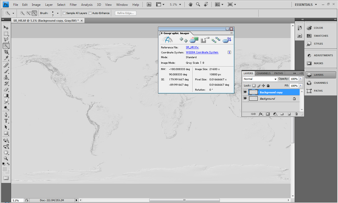

Working with raster imagery doesn't have to be complicated. Geographic Imager® enhances Adobe Photoshop to make working with spatial imagery quick and efficient. It adds tools to import, edit, manipulate and export geospatial images such as aerial and satellite imagery. Enjoy the use of native Adobe Photoshop functions such as transparencies, filters, pixel editing, and image adjustments like brightness, contrast, and curve controls while maintaining spatial referencing. Geographic Imager supports GeoTIFF in Adobe Photoshop and other industry standard raster formats. Mosaic and tile images, change projections, transform, rectify and georeference images based on ground control points. Batch-process your imagery using Geographic Imager and Adobe Photoshop scripting capabilities. Geographic Imager is a great companion to MAPublisher for Adobe Illustrator—prepare images in Geographic Imager and use them in MAPublisher.

Geographic Imager System Requirements
The following are the minimum system requirements for Geographic Imager 3.2 (recommended requirements are mentioned as necessary).
See complete product compatibility for earlier versions of Geographic Imager.
Windows
Adobe Photoshop* CS3 / CS4 (including 64-bit) / CS5 (including 64-bit)
Intel Pentium 4 processor (Intel Core 2 Duo or better recommended)
Windows XP, Windows Vista or Windows 7
2 GB of RAM (4 GB recommended)
300 MB of available hard-disk space
DVD-ROM drive
|||||||||||||||||||||||||||||||||||||||||||||||||||||||||||||||||||||||||||||||||||||||||||||||||||||||||||||||||||||||||||||||||||||||||||||||||||||||||||||||||||||||||||||||||||||||||||||||||||||||||||||||||||||||||||||||||||||||||
更多資訊請點擊訪問

|||||||||||||||||||||||||||||||||||||||||||||||||||||||||||||||||||||||||||||||||||||||||||||||||||||||||||||||||||||||||||||||||||||||||||||||||||||||||||||||||||||||||||||||||||||||||||||||||||||||||||||||||||||||||||||||||||||||||
本資源下載鏈接來自ShareVirus
代碼
▄ ▄
▀▀▀▀▀▀▀▀▀▀▀▀▀▀▄▄▄▄▄▄▄▄▄▄▄▄▄▄▄▄▄▄▄▄▄▄███▄▄▄▄▄▄▄▄▄▄▄▄▄▄▄▄▄▄▄▄▄▄▀▀▀▀▀▀▀▀▀▀▀▀▀▀
▄▄▄██▀███▄▄▄▄
▄███▀▀▀▀█▓█▀▀▀▀███▄
██▀ ░▓ █░█ ▓░ ▀██
▀█▄▄ ███ ░ █░█ ░ ▓██ ▄▄▄▄▄▄▄▄ · ▄▀
▄▄▓▓▓▓▄▄▄ ▄▄▄▄▄▄▄ ▐██ ▄▄█ █▄▄ ██▌ ·▄▄▄▓█▀▀▀░░▓▓▓██▄▄▄▄·
· ·▀▀▀▒▒▓▀▀ ██▓ ▄█▀█▄▄▄▄▄█▀█▄ ▓██ ▀▀▀
██░ ███████████████ ░██
▄█▀█▄ ██░ ██▄███████████▄██ ░██ ▄█▀█▄
▐▀████▄██▓██▄█████████████▄██▓██▄████▀▌
▐▄█▓██▀████▒███████████████▒████▀██▓█▄▌
▀█▄█▀ ███ ███████████████ ███ ▀█▄█▀
▀▀█████████████████▀▀ ▀ ▀▄
█ █ █▄ █▓
▄ █ █ ▄ ·█▓ ██
▀▀▀▀ ▀▀▀▀ ▓█▀ ▓██
▄▄ ███ ███▓
▄▄▄ ▄ ▄▄▀▀ ▄ ▓▒▄▄ ▀█▀ ▄███·
▀▀▀▀▄▄▄▄▄▄▄▄▄▄▄▄▄█▄▄ ▀███ ▄ ▀ ▄██▓
▄▓████▀▀▀▀ █ ▓▓░▄▄ ▀ ▄███▀
▄▄▀ ███████▀▀▄▄▄ ▀▀████ ▄██▀▀
▀▀ ▄█▄▄█▄ ▀ ▀▀·
▄▄▄▄▄ ▄▄▄▄█ ▄▄▄▄█ ▄▄▄▄▄ ▄█ ▄▄
▓███▀███▄ ▓███▀▀██▓░ ▄███▀▀███▓ ▓███▀▀███▓ ▓▓██ ▓███
░░ ████ ███▓ ░████ ▄████ ░███▓ ████ ███▓▄▄▄▄▄▄▄ ▓███ ░░
████ ░███▓ ██████▓ ░████ ▀▀▀ ████ ░███▓ ▓███ ▓███
▄ ▄████▄███▀ ████ ▄▄▄▄▄▄▄████ ▓███▀▀████ ░███▓ ▓███ ▓███ ▄▄▄▄▄▄ ▄
████▀███▄ ▀███▄▄████ ░████▄▄███▓ ████▄▄███▓ ▓███░░░▓███ ███▓
▀▀▀▀ ▀███▄ ░▓▀▀▀▀▀▓▀ ▀▀▀▀▀▀▀▀ ▀▀▀▀▀▀▀▀ ▀▀▀▀▀▀▀▀▀▀▀▀▀▀▀▀▀ zk.
▀██▓ ▄▓▄
▀ ▀ █▄ ▄▄▄▄▄▄▄▄▄▄▄▄▄▄▄▄▄▄▄▄▄▄▄▄▄▄▄▄▄▄▄
▄▄▄▄▄ ▄████████████████████████████████████▓░
░▄ ▄▓░▒▓█████▓░█░████████▓█████████████████████████████▓
▓█ ▄█████▓██░▓█████████░████▀▀█▀▀██▀▀▀▀▀▀▀▀▀▀██▀▀▀▀█▀██▀▀▀▀███▓
▄█▄█▄▄▄▄▄▄▄▄▄▄██▓▄▄▄▄▄▄▓█░▓█▄▄█▄▄▄▄█░▄▓▒░██████████████████████████████████▓
░▓█████████████████████████▓█████████████░███▀▀▀▀▀▀▀▀▀▀▀████████████████████▓
▀▀■▄▄▄▄▄▄▄▄▄▄▀▓▒░▄▄▄▄▄███░▀████████████▓██▄ ░░░░░░░░░▄████▀███████████████▓
▀░▓▓▀▀▀▀▀▀▓███▓▀ ▀▀▀▀▀▀▀▀▀███████▄████▄████████▀█▓░
▀▀ ▀░░░▓▓▄▄▓▒▄▓ █ █ ▀██████▓
░██▓███████ █ ▀ ▓██████▓
▓████████▓█ ▀▄▄▄▄▀ ████████
██▓██▓████▓ ████████
▓████████▓█ ▓██████▓
▓██░██▓██▓█▓ ▓█████▓
▓██░██▓██▓█▓ ▓████▓
▄██░███░█████ ▀▀▀▀▀
▄▄██░███░██▓██▓
████▓███░██▓███▀
─ ────────────────────────────────── ▀████▓██▓███▀ ─────────────────────── ─
░▓█████████████████████████████▓░░ ▀██████▀▀ ░░▓███████████████████▓░
─ ──────────────────────────────────── ─ ▀▀▌▀ ─────────────────────────── ─
▓ ▓
▄ ▄████▓▓▄▄▄ ▄ ▄ [ MOST PROUDLY PRESENTS ] ▄ ▄ ▄▄▄▓▓████▄ ▄
▓█▓ ▓█▓
▓ ▓
░ ░
Geographic Imager v3.2.1 for Photoshop CS3 CS4 CS5
(c) Avenza
Date ..... : 2010-12-09
Size ..... : 25 x 5.00MB
Protection : RLM
Type ..... : Plugin (CS3/4/5 only)
OS ....... : Windows
░ ░
▓ ▓
▓█▓ ▓█▓
░ ▓▓████▓▓▄▄▄ ▄ ▄ ▄ ▄ ▄▄▄▓▓███▓▓░ ░
─ ─────────────────────────────────────────────────────────────────────────── ─
░▓█████████████████████▓░ [ RELEASE NOTES ] ░▓██████████████████████▓░
─ ─────────────────────────────────────────────────────────────────────────── ─
Working with raster imagery doesn't have to be complicated. Geographic
Imager enhances the Adobe Photoshop imaging environment to make working
with spatial imagery quick and efficient. It adds tools to import, edit,
manipulate and export of geospatial images such as aerial and satellite
imagery. Enjoy the use of native Adobe Photoshop functions such as
transparencies, filters, pixel editing, and image adjustments like
brightness, contrast, and curve controls while maintaining spatial
referencing. Geographic Imager supports GeoTIFF in Adobe Photoshop and
other industry standard raster formats, mosaics and tiles images, changes
projections, and transforms and georeferences images based on ground
control points. Geographic Imager is a great companion to MAPublisher for
Adobe Illustrator - prepare images in Geographic Imager and use MAPublisher
to directly import them.
─ ─────────────────────────────────────────────────────────────────────────── ─
░▓█████████████████████▓░ [ INSTALLATION ] ░▓██████████████████████▓░
─ ─────────────────────────────────────────────────────────────────────────── ─
Unzip, Unrar. Check /crack
─ ─────────────────────────────────────────────────────────────────────────── ─
░▓█████████████████████▓░ [ GROUP iNFO ] ░▓██████████████████████▓░
─ ─────────────────────────────────────────────────────────────────────────── ─
We are not taking any applications. We are an invite only group.
─ ─────────────────────────────────────────────────────────────────────────── ─
░▓█████████████████████▓░ [ GREETINGS ] ░▓██████████████████████▓░
─ ─────────────────────────────────────────────────────────────────────────── ─
Our friends, our loyal members and our fair competitors.
You know who you are.
─ ─────────────────────────────────────────────────────────────────────────── ─
░▓████████████▓░ [ RECOiL IN 2010 - ONE MORE IMPACT! ] ░▓████████████▓░
─ ─────────────────────────────────────────────────────────────────────────── ─
本資源帖謝絕任何廣告及與資源無關的評論,凡涉及廣告內容的評論一概刪除處理!
英文名: Avenza Geographic Imager for Photoshop
資源格式: 壓縮包
版本: v3.2.1
發行時間: 2010年
制作發行: Avenza Systems Inc
地區: 加拿大
語言: 英文
簡介:
Avenza Systems公司宣布為Adobe Photoshop 發布Geographic Imager 3插件。該公司已經為Adobe公司的產品提供了很多插件,最出名的就是MAPublisher制圖工具。Geographic Imager 是這一系列軟件的最新版本,該版本將地理空間功能加入了Adobe Photoshop。
“隨著最初Geographic Imager的成功發布,我們非常高興繼續支持Adobe Photoshop 的產品並更新其中的一些功能,” Avenza 公司銷售總監Doug Smith說,“我們現在為Adobe公司的最新Photoshop產品提供空間影像功能支持,並將進一步從總體上加強Adobe Photoshop軟件中的空間影像處理功能。”
使用該插件後,Photoshop可以有以下的功能:
在不破壞空間屬性質量的情況下進行Photoshop自帶功能的使用;
載入空間柵格數據,並保留控制點信息;
輸出其它格式的柵格數據;
使用地面空間點對沒有配准的數據進行匹配;
修改空間影像的投影信息;
空間影像的自動鑲嵌操作;
基於地理坐標的影像裁剪功能;
同Photoshop相關功能的協同工作;
支持多圖層和多譜影像的空間轉換;
地理數據向GeoTIFF格式的轉化;
新增地理坐標系統數據文件;
對Mac和Windows的多重支持;
對Vista/7系統的支持。
Working with raster imagery doesn't have to be complicated. Geographic Imager® enhances Adobe Photoshop to make working with spatial imagery quick and efficient. It adds tools to import, edit, manipulate and export geospatial images such as aerial and satellite imagery. Enjoy the use of native Adobe Photoshop functions such as transparencies, filters, pixel editing, and image adjustments like brightness, contrast, and curve controls while maintaining spatial referencing. Geographic Imager supports GeoTIFF in Adobe Photoshop and other industry standard raster formats. Mosaic and tile images, change projections, transform, rectify and georeference images based on ground control points. Batch-process your imagery using Geographic Imager and Adobe Photoshop scripting capabilities. Geographic Imager is a great companion to MAPublisher for Adobe Illustrator—prepare images in Geographic Imager and use them in MAPublisher.
Geographic Imager System Requirements
The following are the minimum system requirements for Geographic Imager 3.2 (recommended requirements are mentioned as necessary).
See complete product compatibility for earlier versions of Geographic Imager.
Windows
Adobe Photoshop* CS3 / CS4 (including 64-bit) / CS5 (including 64-bit)
Intel Pentium 4 processor (Intel Core 2 Duo or better recommended)
Windows XP, Windows Vista or Windows 7
2 GB of RAM (4 GB recommended)
300 MB of available hard-disk space
DVD-ROM drive
|||||||||||||||||||||||||||||||||||||||||||||||||||||||||||||||||||||||||||||||||||||||||||||||||||||||||||||||||||||||||||||||||||||||||||||||||||||||||||||||||||||||||||||||||||||||||||||||||||||||||||||||||||||||||||||||||||||||||
更多資訊請點擊訪問
|||||||||||||||||||||||||||||||||||||||||||||||||||||||||||||||||||||||||||||||||||||||||||||||||||||||||||||||||||||||||||||||||||||||||||||||||||||||||||||||||||||||||||||||||||||||||||||||||||||||||||||||||||||||||||||||||||||||||
本資源下載鏈接來自ShareVirus
代碼
▄ ▄
▀▀▀▀▀▀▀▀▀▀▀▀▀▀▄▄▄▄▄▄▄▄▄▄▄▄▄▄▄▄▄▄▄▄▄▄███▄▄▄▄▄▄▄▄▄▄▄▄▄▄▄▄▄▄▄▄▄▄▀▀▀▀▀▀▀▀▀▀▀▀▀▀
▄▄▄██▀███▄▄▄▄
▄███▀▀▀▀█▓█▀▀▀▀███▄
██▀ ░▓ █░█ ▓░ ▀██
▀█▄▄ ███ ░ █░█ ░ ▓██ ▄▄▄▄▄▄▄▄ · ▄▀
▄▄▓▓▓▓▄▄▄ ▄▄▄▄▄▄▄ ▐██ ▄▄█ █▄▄ ██▌ ·▄▄▄▓█▀▀▀░░▓▓▓██▄▄▄▄·
· ·▀▀▀▒▒▓▀▀ ██▓ ▄█▀█▄▄▄▄▄█▀█▄ ▓██ ▀▀▀
██░ ███████████████ ░██
▄█▀█▄ ██░ ██▄███████████▄██ ░██ ▄█▀█▄
▐▀████▄██▓██▄█████████████▄██▓██▄████▀▌
▐▄█▓██▀████▒███████████████▒████▀██▓█▄▌
▀█▄█▀ ███ ███████████████ ███ ▀█▄█▀
▀▀█████████████████▀▀ ▀ ▀▄
█ █ █▄ █▓
▄ █ █ ▄ ·█▓ ██
▀▀▀▀ ▀▀▀▀ ▓█▀ ▓██
▄▄ ███ ███▓
▄▄▄ ▄ ▄▄▀▀ ▄ ▓▒▄▄ ▀█▀ ▄███·
▀▀▀▀▄▄▄▄▄▄▄▄▄▄▄▄▄█▄▄ ▀███ ▄ ▀ ▄██▓
▄▓████▀▀▀▀ █ ▓▓░▄▄ ▀ ▄███▀
▄▄▀ ███████▀▀▄▄▄ ▀▀████ ▄██▀▀
▀▀ ▄█▄▄█▄ ▀ ▀▀·
▄▄▄▄▄ ▄▄▄▄█ ▄▄▄▄█ ▄▄▄▄▄ ▄█ ▄▄
▓███▀███▄ ▓███▀▀██▓░ ▄███▀▀███▓ ▓███▀▀███▓ ▓▓██ ▓███
░░ ████ ███▓ ░████ ▄████ ░███▓ ████ ███▓▄▄▄▄▄▄▄ ▓███ ░░
████ ░███▓ ██████▓ ░████ ▀▀▀ ████ ░███▓ ▓███ ▓███
▄ ▄████▄███▀ ████ ▄▄▄▄▄▄▄████ ▓███▀▀████ ░███▓ ▓███ ▓███ ▄▄▄▄▄▄ ▄
████▀███▄ ▀███▄▄████ ░████▄▄███▓ ████▄▄███▓ ▓███░░░▓███ ███▓
▀▀▀▀ ▀███▄ ░▓▀▀▀▀▀▓▀ ▀▀▀▀▀▀▀▀ ▀▀▀▀▀▀▀▀ ▀▀▀▀▀▀▀▀▀▀▀▀▀▀▀▀▀ zk.
▀██▓ ▄▓▄
▀ ▀ █▄ ▄▄▄▄▄▄▄▄▄▄▄▄▄▄▄▄▄▄▄▄▄▄▄▄▄▄▄▄▄▄▄
▄▄▄▄▄ ▄████████████████████████████████████▓░
░▄ ▄▓░▒▓█████▓░█░████████▓█████████████████████████████▓
▓█ ▄█████▓██░▓█████████░████▀▀█▀▀██▀▀▀▀▀▀▀▀▀▀██▀▀▀▀█▀██▀▀▀▀███▓
▄█▄█▄▄▄▄▄▄▄▄▄▄██▓▄▄▄▄▄▄▓█░▓█▄▄█▄▄▄▄█░▄▓▒░██████████████████████████████████▓
░▓█████████████████████████▓█████████████░███▀▀▀▀▀▀▀▀▀▀▀████████████████████▓
▀▀■▄▄▄▄▄▄▄▄▄▄▀▓▒░▄▄▄▄▄███░▀████████████▓██▄ ░░░░░░░░░▄████▀███████████████▓
▀░▓▓▀▀▀▀▀▀▓███▓▀ ▀▀▀▀▀▀▀▀▀███████▄████▄████████▀█▓░
▀▀ ▀░░░▓▓▄▄▓▒▄▓ █ █ ▀██████▓
░██▓███████ █ ▀ ▓██████▓
▓████████▓█ ▀▄▄▄▄▀ ████████
██▓██▓████▓ ████████
▓████████▓█ ▓██████▓
▓██░██▓██▓█▓ ▓█████▓
▓██░██▓██▓█▓ ▓████▓
▄██░███░█████ ▀▀▀▀▀
▄▄██░███░██▓██▓
████▓███░██▓███▀
─ ────────────────────────────────── ▀████▓██▓███▀ ─────────────────────── ─
░▓█████████████████████████████▓░░ ▀██████▀▀ ░░▓███████████████████▓░
─ ──────────────────────────────────── ─ ▀▀▌▀ ─────────────────────────── ─
▓ ▓
▄ ▄████▓▓▄▄▄ ▄ ▄ [ MOST PROUDLY PRESENTS ] ▄ ▄ ▄▄▄▓▓████▄ ▄
▓█▓ ▓█▓
▓ ▓
░ ░
Geographic Imager v3.2.1 for Photoshop CS3 CS4 CS5
(c) Avenza
Date ..... : 2010-12-09
Size ..... : 25 x 5.00MB
Protection : RLM
Type ..... : Plugin (CS3/4/5 only)
OS ....... : Windows
░ ░
▓ ▓
▓█▓ ▓█▓
░ ▓▓████▓▓▄▄▄ ▄ ▄ ▄ ▄ ▄▄▄▓▓███▓▓░ ░
─ ─────────────────────────────────────────────────────────────────────────── ─
░▓█████████████████████▓░ [ RELEASE NOTES ] ░▓██████████████████████▓░
─ ─────────────────────────────────────────────────────────────────────────── ─
Working with raster imagery doesn't have to be complicated. Geographic
Imager enhances the Adobe Photoshop imaging environment to make working
with spatial imagery quick and efficient. It adds tools to import, edit,
manipulate and export of geospatial images such as aerial and satellite
imagery. Enjoy the use of native Adobe Photoshop functions such as
transparencies, filters, pixel editing, and image adjustments like
brightness, contrast, and curve controls while maintaining spatial
referencing. Geographic Imager supports GeoTIFF in Adobe Photoshop and
other industry standard raster formats, mosaics and tiles images, changes
projections, and transforms and georeferences images based on ground
control points. Geographic Imager is a great companion to MAPublisher for
Adobe Illustrator - prepare images in Geographic Imager and use MAPublisher
to directly import them.
─ ─────────────────────────────────────────────────────────────────────────── ─
░▓█████████████████████▓░ [ INSTALLATION ] ░▓██████████████████████▓░
─ ─────────────────────────────────────────────────────────────────────────── ─
Unzip, Unrar. Check /crack
─ ─────────────────────────────────────────────────────────────────────────── ─
░▓█████████████████████▓░ [ GROUP iNFO ] ░▓██████████████████████▓░
─ ─────────────────────────────────────────────────────────────────────────── ─
We are not taking any applications. We are an invite only group.
─ ─────────────────────────────────────────────────────────────────────────── ─
░▓█████████████████████▓░ [ GREETINGS ] ░▓██████████████████████▓░
─ ─────────────────────────────────────────────────────────────────────────── ─
Our friends, our loyal members and our fair competitors.
You know who you are.
─ ─────────────────────────────────────────────────────────────────────────── ─
░▓████████████▓░ [ RECOiL IN 2010 - ONE MORE IMPACT! ] ░▓████████████▓░
─ ─────────────────────────────────────────────────────────────────────────── ─
本資源帖謝絕任何廣告及與資源無關的評論,凡涉及廣告內容的評論一概刪除處理!
- 上一頁:《文本語音閱讀軟件 》(2nd Speech Center )v4.15.10.1202[壓縮包]
- 下一頁:《地圖設計軟件AI插件版》(Avenza MAPublisher for Illustrator)v8.3.5[壓縮包]
相關資源:


- [行業軟件]《三維機械設計系統》(SolidWorks)2012.SP1.0.WIN32|64.MULTILINGUAL[光盤鏡像]
- [應用軟件]《諾基亞S40手機主題制作軟件》(Nokia S40 Theme Studio)[安裝包]
- [行業軟件]《模具設計 》(DelCAM PowerSHAPE v8.0)[壓縮包]
- [多媒體類]《 數碼視頻制作》(Serif MoviePlus)X6[光盤鏡像]
- [應用軟件]《Ps CS4 教程》(Talented Pixie Adobe Photoshop CS4)[光盤鏡像],應用軟件、資源下載
- [軟件綜合][原創]更換電騾前,建議用批處理幫你備份電騾積分
- [應用軟件]《文傑2004(韓文)》(HWP2004)[ISO],應用軟件、資源下載
- [應用軟件]《烈酒 虛擬光驅全系列產品》(Alcohol 120%& 50%)[5.0 Blu-Ray黑盒 & V1.98.7530]中文破解版[壓縮包]
- [軟件綜合]《G-Data網絡安全2007》(G-Data Internet Security 2007)
- [多媒體類]《六角大王4原版CD+原廠教學CD+紙藝大師 中文版》
- [行業軟件]《GIS服務平台企業版》(ArcGIS Server Enterprise)V9.3.1[光盤鏡像]
- [網絡軟件]迅雷9精簡版,破解VIP【私人珍藏】
- [其他圖書]《精品圖書(21)致堂 讀史 管見》
- [教育科技]《英語詞匯突破》第一版[PDF]
- [生活圖書]《運動無極限:體育休閒運動大全》文字版[PDF]
- [生活圖書]《性事保健與壯陽秘方》影印版[PDF]
- [光盤游戲]《橫沖直撞:終極殺戮》(FlatOut: Ultimate Carnage)CLONE版/破解版/破解補丁[ISO]
- [硬盤游戲]《洛克人8-Bit 競技場》(Mega Man 8-Bit Deathmatch)PC免費版[壓縮包]
- [生活百科]《圖解人體經絡使用手冊》掃描版[PDF] 資料下載
- [人文社科]《傷寒論》劉渡舟講解(MP3&壓縮包)
- 《Illuminate Labs海龜渲染器》(Illuminate Labs Turtle )V5.0for Maya 32Bit/64Bit[壓縮包]
- 《軟音源音色盤—民族打擊樂之旅》(EastWest Percussive Adventures LE 2)v1.0[ISO]
- 《屏幕捕捉軟件》(TechSmith Snagit)v10.0.1.58[壓縮包]
- 《Adobe Photoshop 7、CS8.01 中文迷你版》
- 《Marmoset工具包》(Marmoset Toolbag)v1.04破解版[壓縮包]
- 《BluffTitler 金典中文免注冊版下載—完美無水印【多國語言】》(BluffTitler)[壓縮包]
- 《音樂工作站》(Propellerheads Reason v4.0)[ISO]
- 3GP轉換工具 V2.5
- 《數字化音樂制作系統》(Digidesign ProTools LE 8.0)[光盤鏡像]
- 《mental ray 3.7 獨立版》(Autodesk mental ray Standalone v3.7.51 x86/x64 for MAX 2010)[壓縮包]
- 《奧多比數碼照片管理及後期處理軟件》(Adobe Photoshop Lightroom) v3.0 簡體中文/多國語言版 [安裝包]
- 《專業樂譜繪制軟件.Finale.2010.升級包》(MakeMusic Finale)2010.Update[壓縮包]
免責聲明:本網站內容收集於互聯網,本站不承擔任何由於內容的合法性及健康性所引起的爭議和法律責任。如果侵犯了你的權益,請通知我們,我們會及時刪除相關內容,謝謝合作! 聯系信箱:[email protected]
Copyright © 電驢下載基地 All Rights Reserved